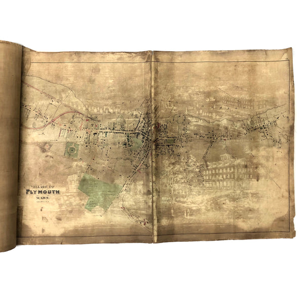


A special thing for a resident of Plymouth, MA, or for a lover of singular maps, too. This 3+ foot long canvas backed annotated map of Plymouth village and environs must have been stored for many years rolled up with a print that left a ghostly toned photographic image on it in the negative (buildings, trees, figures), imparting an especially intense sense of place and history. (With some research I've learned that 2/3 of this map was published in 1879 by Geo. H. Walker & Co. Boston, 61 Hanover St. Boston Mass, with an image of prominent Plymouth residences on reverse, which seems to be the image here--but it is not bleeding through here, rather a copy of that print must have been laid facing it.)
So---the right 2/3 of the map appears to have been published in Walker & Co's Atlas of lPlymouth County Mass in 1879, and maybe the left third too, added to this one when backed with canvas, perhaps. It is mostly that section that features hand-written notes in red and black and graphite, too, making me pretty confident this was a surveyor's map, filling in new details: measurements, plot lines, structures, etc. I'm not a map expert, and haven't done a super deep dive into this, but I really love an old village map with all of the structures and names of families drawn and written in, and this one has quite an aura about it, right down to smelling of old leather bound bound books and the like (a very good scent I think) if one inhales it! Plenty toned, especially at left, but I think just adding to its charm. And it's quite sturdy for its canvas backing, making for easy rolling up and pleasureful unfurling.
38 1/2" x 17 5/8". Toning as evident but sturdy and sound and completely readable. Details give an accurate sense.